The winds of change
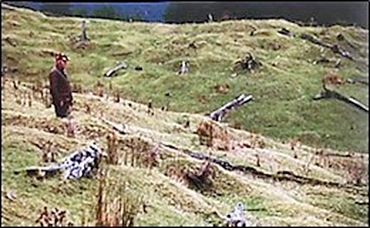
FIG 2: Pits and mounds of trees felled by severe winds during the warm period (1510 to 1620AD) at Wakarara 30 kms north of Norsewood, Hawke’s Bay. Source: Grant, 1996, p. 140.
Contributed
- Enn Jamez examines the natural fluctuations of climate cycles in New Zealand’s past
There is a lot of media reportage on problems of climate warming. Greenhouse gases, like carbon di-oxide and methane, are natural components of the atmosphere.
They have fluctuated over eons of time influencing the warming and cooling of global climates. In recent decades, climate scientists have become concerned over human-induced green-house gasses emitted by modern industrial, petro-chemical, and agricultural practices. To reduce these human-induced gasses, scientists have urged governments to adopt alternative energy practices.
My focus here is, however, on the natural fluctuations in greenhouse gasses and climate cycles and effects that occurred in New Zealand over the last 800 years.
Scientist Patrick Grant spent 40 years studying these natural changes in the Hawke’s Bay. He related several oscillations of annual average temperatures to their impacts on the natural environment, especially forests. He used tree-ring and pollen analyses, radio-carbon dating, changes in silting and erosion of rivers, solar activities, and other means. His conclusions are in Hawke’s Bay Forests of Yesteryear (1996).
His findings about natural changes apply to other regions, like the Eastern Bay, where lowland forests once dominated the landscape.
In the past 800 years, there seems to have been four waves (peaks and troughs) of warmer, wetter, stormy periods followed by cooler, drier, tranquil periods. When the first wave was warming in the 12th century, forests covered about 90 percent of the lowlands of the Hawke’s Bay.
As climate was rising towards a warm peak around 1250AD, forest canopies became very dry or desiccated. Exceptionally strong north-westerly gales blew for weeks on end. Getting into the desiccated canopies, large tracts of forest were blown over. The resulting dry matter was then set alight by lightening, which also affected the remaining stands of ancient forests.
Over time, the mean annual temperatures declined towards a cool dry trough around 1450AD. Forests regenerated, but in the next cycle of warming, tree canopies were again desiccated and exposed to severe north-west gales that came with renewed climate warming.
As these cycles and processes repeated, more forest cover was lost so that by Treaty year 1840AD, forests covered only 10 percent of the lowlands. The rest was bracken fern, tussock grasses, and swamps.
Only small isolated patches of forest remained scattered across the lowlands. There were, however, two quite large patches in northern Hawke’s Bay, east and west of Wairoa, and a large forest in southern Hawke’s Bay. It stretched from north of Norsewood south almost to Masterton and out to Pōrangahau near the east coast (Fig. 1).
Incoming Europeans called this forest the 70-mile bush, although it was 90 miles in length. Its area was around 70,800ha. Running down the length of the bush was a track along which were seven clearings of tussock grasses varying in size (80ha to 200ha).
In the early 1870s, the Government encouraged Scandinavian immigrants into Hawke’s Bay to clear the 70-mile bush for 40-acre farms and to help build roads and railways.
Iwi in this region - Rangitāne and Kahungunu – called this area Tapere-nui-a-Whātonga (Great food basket of Whātonga - because it teemed with bird and fish life).
Whātonga discovered the area in the late 12th Century, when New Zealand was in a warming climate phase. After much exploration, he settled at Heretaunga.
Over the next seven centuries, the archeological record shows Māori erected over 900 settlements across Hawke’s Bay. They may have moved out of forests to the coast when climate cooled, returning when it warmed. They may also have caused some forest fires.
In the late 1860s, after much protestation from local hapū over proposals to clear all of 70-mile bush, the Government’s deal was for every alternate 1/8th of the bush be reserved for Māori. Through craft and guile, it was all in settler hands within 20 years. By 1900, only 1.2 percent of the 70 Mile bush remained (942ha. of 70,800 ha.), now known as Pūkaha (Mt Bruce) National Wildlife Centre Reserve and bird sanctuary.
Flying over grassed areas of the Hawke’s Bay today shows clearly the wind-thrown trees of yesteryear as pits and mounds (Fig 2). They were revealed when North European immigrants burnt off the 200 to 300-year-old regenerated forests and other more ancient trees.

The pits and mounds are aligned in a northwest to southeast direction, evidence of windthrow by the severe north-westerly gales during the 16th century warming phase.
That 1570AD peak gave way to another short, but very cold and dry, period that troughed about 1650AD. Temperatures then quickly rose to a warm peak around 1780AD. It then fell just as quickly to a cold low around 1850AD (when the industrial revolution was accelerating). Since then, the atmosphere has warmed, especially since 1950.
Given this 800-year record of natural climatic changes, one can reasonably expect the current upswing in global warming to eventually peak and then descend towards a cooler trough. This would, it is assumed, happen despite the human-induced component of climate warming attributable to the extra green-house gases generated by industrialization, petrochemical industries, and intensive grassland farming. This prospect should not, however, lessen the urgency for policies to reduce human-induced green-house gasses.
A recent report by Hawke’s Bay Regional Council states that: “Average temperatures are projected to rise by up to three degrees Celsius in the next 70 years … Wildfires, worsening droughts, crops damage and increased pests and disease are expected in Hawke’s Bay by 2090, if effective action isn’t taken on fighting climate change.” That is, action against the human-induced component of climate warming.
The report also says: “Our communities have experienced the impact of severe weather events during Cyclone Gabrielle in February 2023. We know that rainfall is more intense and storms more frequent under increasing degrees of global warming.”
That may well be so, but its salutary to know that a similar rain storm to Cyclone Gabrielle had occurred 85 years prior. The 1938 storm caused widespread flooding and deep silting across thousands of acres of farm. Cars were buried and buildings flooded. Indeed, more lives were lost in the 1938 storm than in 2023.
Neither 1938 nor 2023 cyclones were nearly as ferocious as the extreme gales that “blew for weeks on end” in earlier warm periods – “so fierce it would be hard to believe nowadays” (Grant, 1996, p. 102).
Because the 1938 disaster had been forgotten and therefore seemed unknown to staff in regional and local councils, the civil defence response to the 2023 storm was fraught. Indeed, the post-disaster independent investigation severely criticized Civil Defence Emergency Management, including for it not having planned for worst-case scenarios.
The Hawke’s Bay reports have implications for regions elsewhere. Thus, for Eastern Bay of Plenty, the regional council has warned about climate change hazards, including: “marine heat waves, coastal erosion, inundation and flooding, increased temperatures, landslides, inland flooding, extreme weather and increased fire risk.”